The Best Online GIS for Local Government

Make Amazing Interactive Web Maps That Your Local Residents and Businesses Will Love!

or

USED BY TOWNSHIPS, CITIES, AND COUNTIES

Plumas County uses Mango web GIS

Columbus County uses Mango web GIS

Whanganui District Council uses Mango web GIS

Franklin County uses Mango web GIS

Charlevoix County

Henry County TN e911

Henderson County TN e911

Rajdhani Unnayan Kartripakkha

Gibbons

Ordu Buyuksehir Belediyesi

Parker County, TX

Town of Stoew

Town of Stettler

Catastro Sanaa

Easily make maps your community needs:

Map & Data Portal

LAND RECORDS

ZONING

FLOOD & WATERSHED

Everything you need to quickly and easily move your web maps to a modern cloud based system that your users and GIS team will love.

  • Deploying maps is as simple as point and click
  • Cut out the middle-man and manage your own maps
  • Mobile ready - view maps on mobile, tablet, and any browser
  • Seamless integration with existing systems
  • Give users the tools they need to find answers
  • Zero-friction scalability

“Mango was the one company we researched that met all of our expectations for a fraction of the cost other vendors were charging.”

Becky Osborn
·
GIS Planner, Plumas County, CA

Add Map Tools Specifically Designed for Local Government

Easy Print Export

Easy Print Export

With a single click, export your current map view and selection to a fully customizable PDF ready for print.

Full Text Search

Full Text Search

No complex search forms here, your users can see results across all searchable datasets as they type with Google style search.

Map & Data Portal

Map & Data Portal

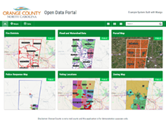
Your portal is the home for all of your maps and data. Allow your users to quickly and easily navigate to the maps and data they need.

Powerful functionality that delivers value and insights across your entire community.

  • Easily integrate your land records map with land record and deed management systems
  • A range of search, query, print and visualization tools to deliver a powerful and effective workflow to your users
  • Support for all major vector formats
  • Raster support for up to date aerial and satellite imagery
  • Adapt to your terminology or language (L10n)
  • Analytics integrations for continuous improvement
“What immediately impressed me was how quickly I was able to upload data and get a useful map published. Other products I tried required more time in the learning curve than I could afford.”
Alan James · MIS Director, Columbus County, NC

Give Your Community the Maps They Deserve

Test drive Mango with a 30-day free trial - No commitment!