Are your users provided the best experience possible? Here's why you need to start making smaller more focused maps.
A common mistake for local governments to make when creating their web GIS is to create one map that does it all. In this article I will explain why this is not the best approach and the benefit of having several small and focused maps rather than one mega map.
There are numerous reasons for putting all of your layers in one map. Traditionally the main incentive was cost, back when maps used to be hugely expensive to create, requiring coders, servers and expensive software licenses, web mapping could take a huge chunk from a county, city or township's budget.
Under those conditions, it made sense to squeeze as much as possible into a single map.
The second most common reason is an attempt to replicate the desktop GIS environment, these web maps can be identified by their excessive number of available layers and more buttons and toggles than the flight deck on a passenger plane.
A desktop GIS may be intuitive to a desktop GIS user, but I can assure you it will be intimidating for your average resident who likely doesn’t even know what ‘GIS’ means, never mind being familiar with the desktop software.
The first lesson we are taught in any design discipline is to remember that our users often don’t see the world in the same way we do. And that’s true of mapping.
For your users, mapping means Google Maps.
It doesn’t mean ArcGIS.
They're used to simple controls and an uncluttered interface. Therefore that’s what we should strive to replicate.
Also, Google Maps is very focused. Its primary objective is to allow users to quickly and easily find a location on a map and it does that extremely well.
Your maps too should be a scalpel rather than a Swiss Army knife; with each map being refined for a single purpose such as locating land parcel records or checking the zoning for an address.
Your Map Should be a Scalpel
Not a Swiss Army Knife
So before we dive deeper into what a focused map looks like and its benefits let's first look at what we shouldn't be doing.
For the purposes of this article let's call the small focused maps ‘story maps’ and let’s call the large all encompassing maps ‘portal maps’.
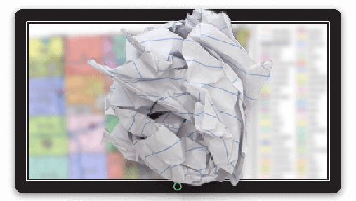
A portal map has the following traits:
-
A very general name such as "Orange County GIS"
-
No description text
-
An excessive number of layers (>5)
-
An excessive number of tools and buttons
-
No clear path for the user to follow to achieve their desired results
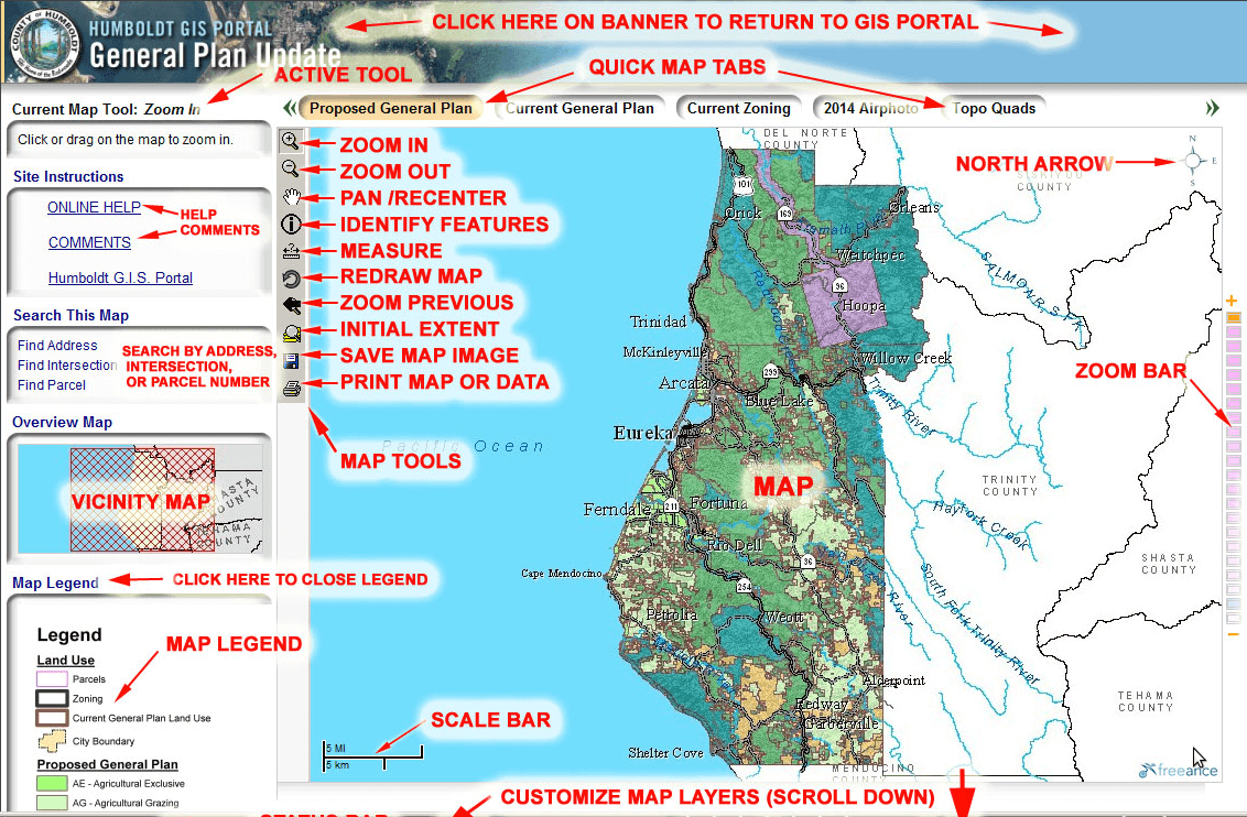
Portal Map: If your map needs this many instructions, you're doing it wrong
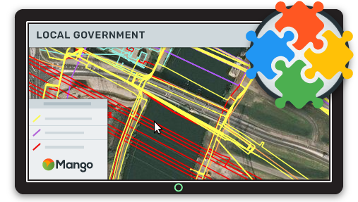
A story map has the following traits:
- Descriptive name e.g. Orange County Land Parcel Lookup Map
- Details description text that tell the user how they are expected to use the map
- The map only contains layers that directly assist in the task described in the map name and description
- The map only contains tools that assist in the task described in the map name and description
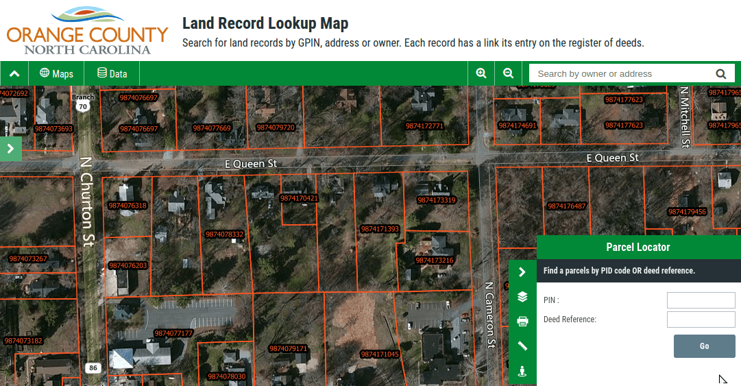
Story Map: Clean, simple and focused
So now we know the difference between a story map and a portal map let's take a look at the benefits the story map has over the portal map.
1. Easier To Find
Most internet traffic is driven by search engines. Search engines such as Google use very clever algorithms to assess the relevance of web pages to specific key phrases (search terms).
A number of factors are in play, but the main method Google users is to analyze the text on the page to ascertain what the page is about. It gives particular importance to the URL of the page, the page title (displayed in the browser tab) and the header text at the top of the page.
So let's take a look at our two maps for example.
Portal Map
Title: Orange County GIS
URL: https://orange-county.gov/gis
Page header: Orange County GIS
Description: Welcome to the Orange County Interactive Web GIS
Story Map
Title: Orange County Land Parcel Lookup Map
URL: https://orange-county.gov/gis/land-parcel-lookup-map
Page header: Orange County Land Parcel Lookup Map
Description: Enter a name, address or parcel ID into the search box in order to locate land records in Orange County
Based on the information above, if a user goes to Google and types in "find land records information for Orange County", which one do you think will appear higher in the search results?
The Portal Map will be lucky if it makes the first page of the results.
Data shows that results on the first page of Google typically get around 72% of all clicks - with the first two results taking the lion's share of around 50%.
If your map is off the first page, you'll be seeing click through rates of under 1%.
The Story Map, on the other hand, will likely be in the top three results, if not the top result, as it's extremely relevant to the search query. That's potentially a wide audience who will find your map.
Search engines love relevance, so use it to your advantage by tailoring the available text to your user's intent and you'll increase eyeballs on your maps.
2. Easier To Use
In most cases the users of local government web GIS systems don't want a web map, what they want is an answer to a question.
The question might be:
- Where can I find the deeds for 1035 Old Tram Road?
- What is the zoning code for 73 Main Street?
- Is Greengate Farm prone to flooding?
Your job is to allow local residents and businesses to answer these questions in the fastest and easiest way possible.
Users don't want to go to a map portal and spend half an hour sifting through layer after layer and tool after tool to find the combination that can give them the information they seek.
What they want is to not have to think, the map should be so clear and focussed that there is only one way that is can logically be used and as a result, they can find their results with minimum fuss.
The map should already have the relevant layers turned on, the tool that will get the job done should be front and center and there should be a name and description on the map that doesn't leave the user wondering what to do next.
3. Free From Distractions
"If I had more time, I would have written a shorter letter."
It's easy to include everything but the kitchen sink, it's much harder to think about which elements are absolutely necessary for the task at hand.
The same goes for your map. You should strive to only include elements that make it quicker and easier to achieve the task at hand, everything else in noise.
This is especially true of your choice of map layer and tools.
Before you add another tool or map layer you need to ask yourself if it's really necessary for the primary task of the map, or if it's being added because now the map is trying to solve two problems.
If so you should consider making a new map that is dedicated to that second task rather than trying to shoehorn it into the current map.
Managing Lots of Story Maps
A portal map may not be as accessible or usable as a story map but it does have one benefit, all of the maps and data are in one place.
In most cases, the users of local government maps are only interested in one map at a time, but you may also have a number of power users that need to be able to easily navigate between multiple maps.
For these users, you should use a ‘map portal’.
So the first thing you are probably wondering, is what’s the difference between a ‘portal map’ and a ‘map portal’?
As we already know a portal map is a single map application that contains all of the datasets and tools. A map portal is a homepage that links to each of the individual story maps.
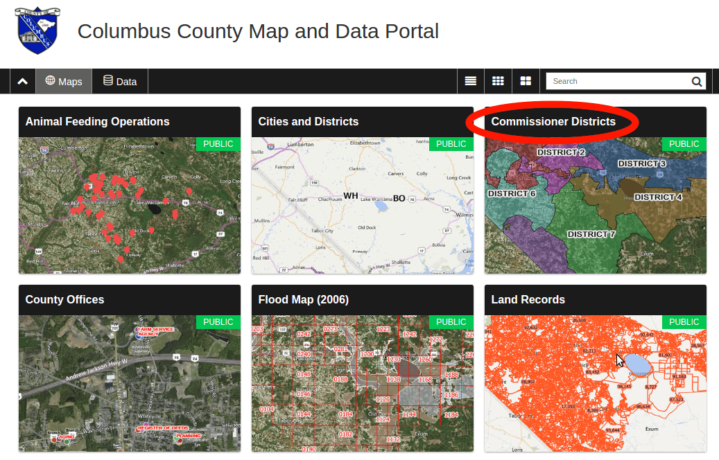
The user can enter the map portal, navigate or use the search box to locate the map that they need for their current task then easily navigate back to the map portal to select another map.
This workflow gives your users the best of both worlds, you maps remain small and focused which is good for accessibility and usability but the user is also given an easy path to access maps for completing other tasks.
Conclusion
If you haven't done so already you should be making plans to move away from portal maps and towards story maps that increase accessibility and usability. Your users will thank you for it!