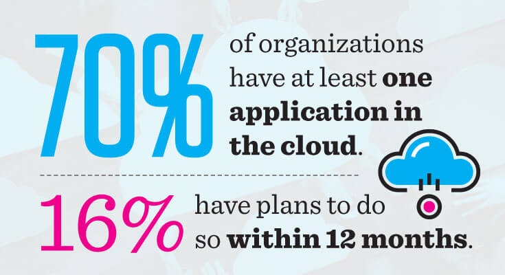
70% of organizations have at least one application in the cloud. Here are five reasons why you should do the same.
Most folk fall in to two camps: either the cloud is where you get stuff done, or it's that shiny thing you've dropped in the too-hard basket because, well, you've got that server right there, and it's running fine for now.
If you lean towards the latter, I recommend taking a few minutes to consider the cloud, and what benefits it might bring to you as a publisher of GIS maps, and your community - you know, the people you're making maps for.
First, let's define the two choices available for web mapping platforms:
- Cloud-based GIS platforms are hosted on a vendor's servers and accessed through a browser.
- On-premises GIS platforms are installed locally, on an organization's own servers, directly hosting web traffic to locally stored web maps.
Cloud systems primarily are offered as monthly or annual subscriptions, while on-site installations generally have a significant capital expense, along with ongoing maintenance contracts to keep software licenses current.
Subscription models allow for a low financial barrier to entry and are one of the leading reasons why organizations make the move to the cloud.
According to the IDG Enterprise Cloud Computing Survey of 2016, 70% of organizations now have at least one application in the cloud. This is up from 12% in 2012, showing cloud platforms have become a staple of business infrastructure.
So what are the primary benefits cloud GIS has over on-site deployments?
Let's take a look at 5 reasons why cloud mapping is better for your county, city or township.
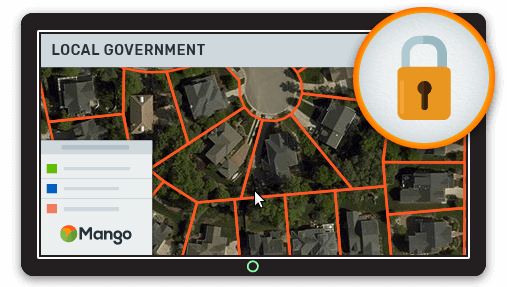
1. Cloud GIS Is More Reliable Than Legacy Server Systems
Those servers in your back room need constant attention. Hard disks fail, the UPS will fail, the server will fall over. It's a fact of life.
It's simple to dismiss failure as an irritant until it's too late, and after all, those servers are fine.
For now.
Next thing you know, you're knee deep in terminal windows rebooting servers, restoring backups, and swapping out dead drives. It could be worse - it could be 4 AM and you're down in that same hole sweating to get the server back online. No biggie. You'll get a good night's sleep tomorrow.
But what does that downtime really cost you?
Besides the financial cost of lost business and disruption to your users, it's going to hit you where it hurts most by taking you away from what you should be doing.
Your online mapping is supposed to be delivering answers for your community, but when you're spending more time maintaining the system than you are maintaining your data, the value of your efforts is exponentially reduced.
So, when your server goes down at 4 AM, who would you prefer gets the call?
With Mango powering your online GIS, that's our job. We'll let you wake up refreshed from that recurring dream about reeling in amberjack, because we were the ones getting the alerts, up at 4 AM resolving issues.
At Mango, nothing is more important than your data.
We leverage the power and stability of Amazon Web Services (AWS) - the original and the biggest distributed cloud computing service on earth.
It's proven reliability means we can ensure full redundancy of your data (meaning we store duplicate data across multiple disk arrays in multiple data centers, so failure of one disk never causes in data loss), and fault tolerant infrastructure which provides us portability across hardware and data centers to restore services in the blink of an eye.
We maintain 7 day rolling backups, where a complete copy of each server (data, and operating systems) is generated each day.
In the most extreme scenario of catastrophic failure, Mango snapshots can be reinstated instantly.
2. Cloud GIS Requires Less Maintenance Than in-House Systems
Reliability is only as good as the maintenance that goes into the system. A heavy burden of on-site servers is the constant attention they require to keep running.
Patches, upgrades, replacing failed components.
Each time requiring your time, your expense.
But it's not just the server that needs maintaining. The applications need just as much attention.
Developing custom applications on the back of SDKs might seem like an ideal way to deliver highly customized applications that do exactly what you need. Until the SDK is revised and you need to recode, or the API is deprecated and you realize it's going to take 3 months of coding to bring up to date.
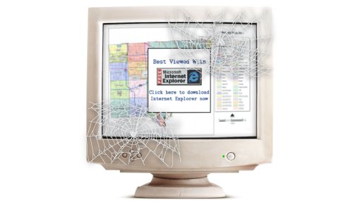
It doesn't take long to find counties with custom built map applications like this. They looked good and worked great in 2005 when the local GIS software consultant built it, but hey, it's 2017 and, the iPhone will celebrate its 10th anniversary this year.
That old custom map your serving? Yeah, it doesn't even load on an iPhone.
These systems litter the internet like old VGA cables stuffed in a cupboard. Once upon a time delivering crisp 640x480 resolution, now obsolete and useless.
When building online mapping applications, it's likely you'll need to stay on top of a whole stack of technology. Patching, updating, coding, deploying.
In a small team where labor is finite, this means a large chunk of your labor is working just keeping your maps online while you keep putting band-aids on the hemorrhaging servers.
With Cloud GIS, there is no server for you to maintain - the vendor is taking care of it.
This lets you focus on the important things - maintaining your data and delivering beautiful and accessible web maps with the freshest, most compelling data for your community to make use of.
3. Cloud GIS Is Cheaper Than on-Site Installations
With cloud deployments, you remove a complete level of acquisition and deployment expense.
Where once you had to acquire hardware, configure and install your software stack, and code against it, now you can simply sign in and start making maps. No infrastructure means no infrastructure costs.
Labor costs, acquisition costs, development costs, all reduced.
With the high upfront and maintenance costs associated with on-site installations, it's easy to forget the hidden costs.
Have your own solar array on the roof? Great, you'll need it, because those servers chew through electricity like it's free taco Tuesday.
Most of us don't even consider electricity costs as part of the IT budget, but it's a very real, and a very large chunk of the cost of delivering online maps. Say your average server consumption is 800W an hour - that's 19.2kWh a day, 7008kWh a year.
Even at a low average of 12c per kWh, that's $840 a year.
Just for your server.
Don't forget the air-con. Servers are sensitive petals and like to have the air on sub-arctic 24/7, unless you're keen on replacing them every 5 years.
I'll let you do your own sums for the A/C power consumption.
A 5-year server lifespan is not uncommon, but it is commonly overlooked when planning on-site installations.
Think for a moment what this means: besides regular maintenance expenses, every five years you're probably going to need to replace your entire setup, including software licenses.
A cloud approach entails a periodic subscription cost, which may mean higher recurring monthly fees than in-house servers, but this doesn't necessarily mean higher long term costs. Look forward ten years, and on-site expenses begin to look worrying.
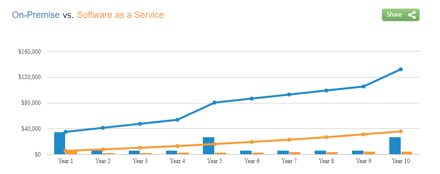
You aren't getting dinged for 5-year spikes in capital expenses because the heavy lifting is being done by your cloud provider.
Maintaining and upgrading their services to better servers and the latest software behind the scenes is their remit, which provides you the benefit of stable and available services.
It's one of the more glaringly obvious benefits to cloud GIS, once you've assessed TCO - Total Cost of Ownership.
Even if you have an on-site solution in place, I recommend you take the time to run the numbers on your TCO.
Without considering the cumulative costs of your in-house solution five years ahead, comparing on-site to cloud platforms in the true light of day just isn't possible.
Let's look at this from another angle: Typically, as your deployment expenses increase, so too will your infrastructure costs. So too your maintenance costs.
As each part fails, new parts must be purchased. As we've seen, on-site assets eventually need to be replaced entirely, and if your existing outdated software isn't compatible with your new hardware, your expenses take yet another hit.
Another commonly underestimated expense of cloud computing is bandwidth. Serving all those map tiles direct from your server room means a lot of bandwidth. If your traffic goes up, your bills follow right along.
This is not the case with cloud platforms like Mango.
With cloud platforms, you only upgrade to a new quota as your needs increase, not when your infrastructure breaks or becomes obsolete.
When it comes to pricing, some cloud platforms want you to chant a series of incantations and perform complex equations just to generate a ball park figure of what you might pay based on your estimation of monthly map views and how many queries or address searches they might perform.
Mango doesn't go in for all that. We prefer a straight-forward, no nonsense philosophy: fixed pricing. Pick the number of maps and data storage you need from our plans, and that's all you'll pay. Whether you have a thousand or fifty thousand map views. Dozens upon dozens of daily queries. A gigabyte of bandwidth, or tens of gigabytes. Fixed.
No surprises, no unexpected charges, ever. Knowing exactly what you'll pay for the upcoming budget period.
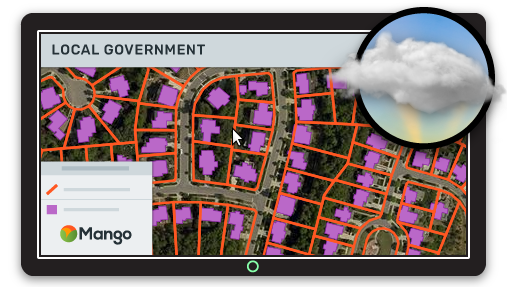
4. Cloud GIS Easier to Keep up-to-Date
Maintaining a cloud GIS means only focussing on what's most important: your data.
By using cloud based GIS, you never have to think about infrastructure again.
High tempo updates are also simple in the cloud. Integrations with cloud storage providers like Dropbox, and features like WMS support.
If you have documents, such as title deeds, photos or inspection reports stored in an online document management system, you can link these to features in a map in Mango using a simple URL API that allows users to drill down from property to deed, tax records, or reports, without having to navigate through these systems independently.
Say your dataset has a column called ID that contains the code for a deed record on an online database, it's simple to build a URL from within the Mango's custom pop-up tool that links to the deed document by inserting the ID variable. Now on each property, you've got a popup that links to https://orange-county.com/deeds?id={ID}, with {ID} being the unique deed identifier like so, https://orange-county.com/deeds?id=019865.
When clicked the user will be taken to the specific deed in the County's external deed management system.
Simple yet powerful features make managing your mapping and records systems a breeze.
Reuploading datasets from your desktop is as simple, and every map using that dataset will regenerate to reflect the changes, both the visualizations and the info popups for each feature.
Automation provides yet another level of ease. Link a cloud storage platform like Dropbox to your online mapping system and every time you make changes to your data on your desktop, Dropbox uploads the changes, and Mango pulls the new dataset.
5. Cloud GIS Mapping Is More Accessible for Your End Users
This is the killer that is often overlooked by mapping professionals:
Who are you actually making maps for?
By and large, local government maps are for constituents. Ordinary folk in your county or town that have a question about their community. Maybe their property tax rates, or zoning classifications for a new business they're thinking of opening.
Let's think about these folk for a moment. How many of them use maps every day?
Probably a lot of them route their commute with Google maps or Apple maps.
So they know how to interact with online maps.
Now, how many do you think have completed their MScs in Geospatial Technologies?
Not many, right?
And how many do you think have used the GIS you've got open on your desktop, let alone know what it's called?
Fewer still, if any.
Should you or I expect Joe Public to understand a complex GIS interface with dozens of layers, obscure terminology, and complex query functions?
Hopefully, you answered a resounding, “No!”
So, Joe Public is using your maps. Where's Joe looking at them? Probably on his phone. What else does Joe do on his phone? Checking the news, getting the football scores, or checking out the weather for the fishing trip this weekend.
Here's the thing: the way people interact with the web is inherently different than how we use specialized desktop applications like Arc or QGIS.
There is some crossover as desktop makers are taking note of the huge body of research on user interaction and experience on the web, but one thing is certain: Joe doesn't give a damn about your desktop GIS. His time on the internet is spent asking google questions, finding answers. Fast.
Joe doesn't want to learn a new interface, and nor should we make him.
Joe also doesn't want to install out of date plugins to use your maps.
So instead of making the mountain come to you, it's time to take your work to the mountain.
If there's one thing the internet has shown us, it's that attention spans are shorter than ever.
Current research shows we now have lower attention spans than goldfish. At least I think that's what it said. I got distracted halfway through.
The point is, people don't bother trying to fix problems with websites they visit.
If it doesn't work, immediately, they simply leave and never come back.
Remember all that time you invested in developing custom Flex map applications?
Flex, the widely used SDK for Flash, and still used by a huge number of ArcGIS Server deployments, simply doesn't work on Android or iOS.
See that puff of smoke? That was half your audience evaporating into never coming back land.

Then, back in 2016, the big browsers all blocked Flash by default.


Chrome, Edge, Safari, and Firefox. Gone.
That's the other half of your audience gone.
In fact, most tech publications recommend users uninstall flash altogether due to the security risks associated with outdated software. Worse still for those with maps made with Flex, Adobe, the maker of Flash just announced they're sunsetting the technology.

The bottom line: If you're serving maps running on Java, Flash, Flex or Silverlight, they're just not working.
Users aren't seeing your maps, and they're no longer providing any value to your community.
They're a liability, and that's putting it kindly.
The simple beauty of modern web based GIS platforms that are built on HTML5 standards is that they just work. Everywhere.
HTML5 compliant platforms provide full native support across web browsers, mobile devices, and smart TVs. Unlike the bright and dazzling shooting stars of web browser history, it's not going away anytime soon.
HTML5 is standards-based with open source, and it's since its inception in the mid-90s it's been the cornerstone of the internet as we know it, and it's only getting better as the standards are under constant development by the World Wide Web Consortium.
Moving away from legacy platforms -- whether they're sitting in your server room or you're hosting them online -- towards standards-compliant platforms ensures the widest compatibility for your users.
This means future-proof online mapping deployments.
More reliable, cheaper to implement and maintain, and easier to keep up to date.
These same issues that Joe Public faces also apply to the business and official users of your maps - the County Tax Assessor, local realtors, and other local businesses that need your maps to do their job.
They have the same basic needs as Joe Public: efficient tools that work on their devices, that let them answer their own questions about your community.
They may have a higher technical knowledge, and while they may have more patience to bear with your archaic system that only works on that old Windows 2000 desktop in their back office, it's not because they enjoy using it. They've got a job to do and there's no alternative.
Providing easier to use maps with greater functionality and availability will make their lives easier, just as it will for Joe Public. Now, instead of haranguing you at the bar on Friday night, they might just buy you a beer.
Summary
Mango helps a lot of counties and townships whose existing systems look like they're ready to hit the canvas and won't be getting up.
They were running on-premise legacy technology that was no longer achieving their county's desired functionality requirements and operational goals, and they needed a system that provides rapid deployment, lowered total cost of ownership, and delivered an easy-to-maintain system that enabled business continuity and simple integration with existing systems.
But they had some smart folk on board who saw that final server-failure sucker-punch coming, and they did something about it.
They moved to Mango.