The paradigm shift to cloud based computing is driving one of the most transformational periods in history for business and government. Are you on board?
Cloud mapping is driving enormous change in the way local government communicates with residents and business.
Just over decade ago, Google introduced the world to a new way to discover, search, and interact with our own communities via online street maps and satellite imagery in Google Maps. It cleared a path forward for the application of GIS via simplicity and accessibility.
Legacy mapping systems in use across the US have reached a point where they’re more burden than benefit. A glance across the applications being served today and you’ll find ancient bespoke applications with long expired support agreements which are expensive and specialized to maintain – if they can be maintained at all. They’re opaque and maze-like, and all too often these systems fail to deliver the most important element: delivering answers. They exclude the public through technical language and byzantine processes familiar only to GIS professionals.
Democratizing local mapping requires a high level of usability and accessibility – users demand always-on services, instant access, on any device. Sounds complex, and complexity means cost – but it doesn’t have to be that way.
Reigning in Costs
In an economy where the purse strings are forever tightening, physical on-site setups are no longer feasible, nor necessary. Suggesting an in-house server setup in a small government agency today would probably have your colleagues reaching for the straight jacket.
Supposing you have the expertise on hand, you’ve got to establish your needs, procure appropriate hardware, procure software with complex pricing and licensing restrictions, setup dedicated network infrastructure, and configure dozens of applications. You need physical space, cooling, and you’ve got to keep it running 24/7 with fallback UPS’s. And then, you’ve got to back it all up, regularly.
Existing systems are equally problematic and expensive to maintain. Your IT staff will need to be continually maintaining on-site infrastructure, and in the case of hardware failure, replacing and re-configuring. Specialist equipment may also need contract staff to deal with configuration and repairs.
When your installation reaches it’s maximum workload, scaling on-site servers is a new procurement, and not something that can be initiated in a few minutes.
The idea of “moving to the cloud” has become so ubiquitous that it’s almost cliche. We all know it’s probably the right thing to do, so let’s look at some tangible benefits that counties and townships can deliver to constituents and local business right now.
Instant Implementation
Cloud implementations benefit from drastically faster roll-outs. Web GIS platforms like Mango have the infrastructure already worked out, so you can dive straight into into creating map applications. Open up a browser and you’re ready to go.
You can have a suite of maps styled and published along with an open data portal of public datasets up and running in just days, and all without writing a single line of code.
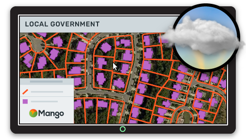
Even without dedicated GIS team, data rich visualizations with ready made customer queries can be configured easily. Mango offers a simple interface for visualizing and styling datasets, what-you-see-is-what-you-get editing panels for enriching maps with complementary images, video, or instructions, and targeted tools that let users dig deep for answers.
Mango is an innovative cloud platform that incorporates mobile, social and analytics technologies ensuring your reach is maximized and you can leverage data to continually improve the services you offer.
Cloud mapping is surprisingly cost-effective, but it’s primary differentiation is simplicity. Initial setup costs are next to nothing – not to mention life-time costs.
Mango offers a straightforward pricing model that means you always know what you’ll pay. No calculators, no credits, no complex licenses, and no unexpected surprises on your invoice. It’s also extremely flexible. Need more storage? Click to upgrade, and keep on working.
Expenditure on hardware, utilities and IT labor will be greatly reduced. Switching to cloud mapping frees your IT team from dealing with data storage and server management, and allows them to focus on other priorities, and opportunities for cost savings throughout the county.
Information security and compliance is a critical ingredient, and most counties will find that the infrastructure behind services like Mango offer increased security when compared to self-managed on-site solutions, and adhere to dozens of compliance programs including PCI and ISO.
Columbus County, NC uses Mango to deliver spatial insights to 17k visitors each month.
— Case Study: NC County Map Portal with Over 17k Visitors/month
Community Benefits
A web GIS platform is easier to implement, easier to maintain, and most importantly, provides efficiencies that legacy systems simply can’t.
Systems that make updating dataset and maps a laborious prospect belong in the past. Now, with tools like data synchronization, your maps can be kept updated near-real-time with workflows that integrate seamlessly into existing practices. Your road works crew can be providing on-the-ground repair information that updates public maps on the hour.
Cloud based mapping means delivering maps that enhance civic engagement and helps local business, but it doesn’t have to mean high level of cost. Counties are ideally placed to recoup the benefits of cloud mapping with surprisingly low barriers to entry.
One of the greatest problems with old models of service delivery is the slow entropic march of bureaucracy. Lines and request forms really can be a thing of the past. New models of service delivery such as cloud based mapping are unlocking citizen participation and satisfaction.
Static mapping is dead – at least in the traditional sense. Locking up maps in paper in offices means the burden on county offices to provide services remains.
We can remove inefficiencies of hand processing requests for GIS maps by empowering citizens to find their own answers, and generate relevant, localized maps for printing – on-demand – with whatever data layers they need. Goodbye GIS map request inbox.
When it’s so simple to publish land and parcel maps to make them easily accessible to the public for viewing and downloading, the question isn’t why, but why not?
Mango works with counties that have a genuine commitment to deliver meaningful differences in local communities, and they’re seeing amazing results from serving their community data through simple, targeted cloud map applications.
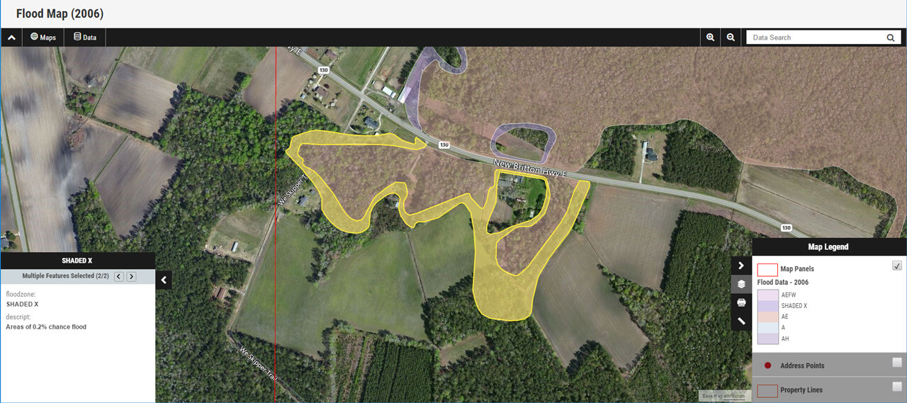
With an online parcel mapping, Joe Appraiser visits a plot of land, opens a flood map on his mobile, geolocates himself, and generates a localized map of the 1 in 100 year flood hazards within or near the property to include in his appraisal report. Joe can also view deeds and property tax history with bi-directional links between maps and county databases.
Switching Makes Sense
To a large extent, the public knows how to extract answers from maps already – they’re answering questions every day about their world – so it’s our job to simply give them access to a greater breadth of data and provide simple but effective tools that can extract answers. Tools that let them keep abreast of their community: hazards, disaster recovery efforts, public health inspection reports, pothole repairs or street closures. They need maps that allow them to query data and drill down to find highly relevant answers. Mango’s cloud mapping platform for local government can deliver those answers, and deliver counties significant cost savings in the process.
The public are engaging with maps at a level and complexity not seen before. That endless supply of data in everyone’s pocket is slowly but surely eroding the barriers of specialized technical systems and enabling democratic access.
Those barriers still exist, and they’re rooted in the old systems sitting on servers in local government offices across the country.