The current approach to online GIS data management has had it's day. Spinning up a single map deployment, filling it with assorted layers, and shooting it into the world is easy, but from an end-user's perspective, it's ungainly, unorganized, and hard to navigate. There’s got to be a better way.
Fast forward to the next scheduled data update, and think about how you'll maintain those maps? Custom deployments can be fragile, and chances are updating your map deployments and data visualizations is going to be time consuming.
You can always make more, and if you've got nothing but time on your hands, well, at least you've got something to keep you busy, right?
If they’re throwaways, then nothing lost; but your data isn’t throwaway. If you’re serious about exploring data through web map visualizations, discovering trends, and extracting answers, then you’ve invested more than you’d care to think about in collecting and preparing that data; it’s the lifeblood of your organization.
If that sounds familiar, you're making it harder than it needs to be to get your users to their answers, and harder for yourself. There is a better way.
An online GIS platform should be capable of more than just deploying maps; it's about streamlining your entire data collection, publication, and online GIS data management process into a systematic and secure workflow that let's you best communicate your data and helps users easily find their answers.
Mango makes it simple.
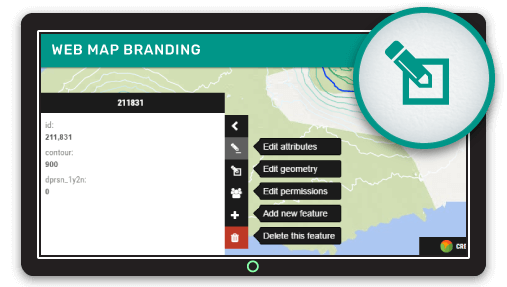
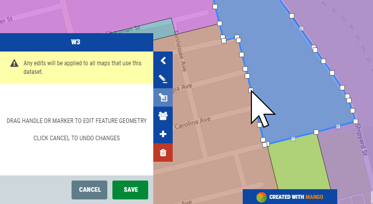
In Mango, you can edit attribute data of features in datasets, or edit the geometry or location of point, line, and polygon data. Best of all, with Mango, online GIS data editing is done right from within your maps, giving context to the data. If you have multiple maps using the same data source, updating the data once propagates changes throughout all of your map visualizations using that dataset.
If your current workflows include a desktop GIS, then you don't have to change anything. Keep your data editing and processing in the desktop, and simply refresh datasets with the re-upload tool. Again, all maps using a dataset that is reuploaded will be reprocessed, and your maps updated to reflect the changes.
For more complex editing that requires a desktop GIS, Mango's Data Sync tool offers data management workflows that don't even require your to log in to Mango. Complete complex editing on datasets on your desktop, and Data Sync detects the changes, and propagates those edits through all maps using that dataset. Whether you have one map or one hundred, each map layer visualized with the updated dataset will update, meaning you don't have to lift a finger to ensure your users have access to the most recent map visualizations.

Like all Mango features, achieving simplicity is simplicity itself. Maintaining your data with Mango's online GIS data management tools is as simple as a point and click.
What you won't need is:
- Programming skills
- Desktop GIS expertise
- Explaining to finance each month why you’re always over budget with unexpected usage credit consumption
Generous storage limits and granular security control make Mango a suitable choice for organizations of all sizes and budgets.
Take a look at this short video that explains Mango’s data management features.
