St Joseph County Parcel Remapping Program
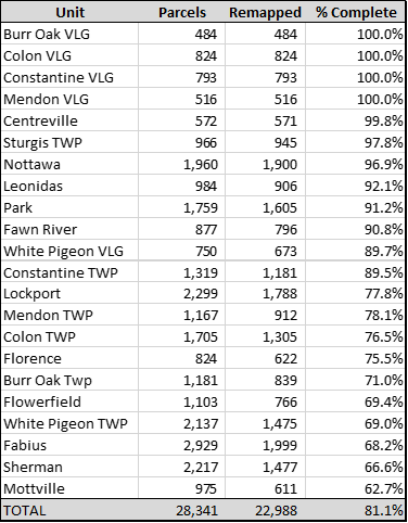
The St Joseph County GIS Department has committed to significantly improving the accuracy of the parcel data within the county. As of 2/1/23, 22,988 parcels have been remapped to within a minimum of +/- 3 ft accuracy. The areas remapped are shaded GREEN on the map. This represents 81.1% of the 28,341 county maintained parcels. The remapping effort will continue as additional accurate section corner coordinates are identified.
Program Status as of 2/1/2023:

Parcel Line Accuracy Map
Interactive map showing the estimated accuracy of St Joseph County parcel lines and the status of the Remapping Project.
Section Corners
Estimated Accuracy
2023 Remonumentation Project Corners
Parcel Accuracy
Center your desired location under the cross hairs and click the launch streetview button.
Measure distances
Measure areas
 CREATED WITH
MANGO
CREATED WITH
MANGO
CREATED WITH
MANGO
Selection Table