General Plan Designations
This General Plan Designations interactive map represents land development boundaries and policies that are applicable to (site) specific properties within Plumas County. The broad purpose of the Plumas County General Plan is to express policies which will guide decisions on future growth, development, and conservation of resources as well as their cumulative impact on future environmental conditions in a manner consistent with the goals and quality of life desired by the County's residents.
Per Title 7, Division 1 of the Government Code of the State of California, Article 5, Section 65300 et seq, the County of Plumas is required to adopt a comprehensive general plan to guide its future physical development. Under State law many actions on private land development, such as specific plans, area plans, zoning, subdivisions, and other decisions must be consistent with the general plan.
Since the GIS data was developed for planning purposes and use in publication of maps and/or database creation, the data is for illustrative purpose only and is not suitable for parcel specific decision making.
Therefore, the GIS data presented in this interactive map are approximations and further land development determination is at the discretion of Plumas County planning staff which may require a parcel specific site review (to draw parcel specific conclusions).
For more information, please visit Plumas County Planning Services

General Plan Designations
General Plan Designations represents land development boundaries and policies that are applicable to (site) specific properties within Plumas County.
-
How to Navigate the Map
NOTE: Hover your mouse pointer over a map tool icon to display the name of a particular tool. See the list below for the function of that tool.
THE MAP TOOLS
Scalebar / Latitude & Longitude / Create Bookmark / Share Bookmark /Zoom Tools / Print Map / Refresh Map

Located in the upper right-hand of the map screen
Add Bookmark
Save frequently visited places or features.
Share Place
Share your bookmark of a place or feature
Zoom-In
Click on the " +" to zoom in at a generalized location. To zoom in to a more specific area, click on the map itself. The map will be redrawn at twice the current resolution. The map will be centered on the point where you clicked.
Zoom-Out
Click on the " -" to zoom out at a generalized location.
Print
Create high quality map prints with feature highlights and popup windows.
Refresh Map Tool
This tool when pressed takes the map back to its default position.
NAVIGATING TOOLS
Information & Tool Pop-Ups
Open and close the Feature Information, Tool Bar, and Header/Menu pop-up outs by clicking the

Moving Around
To pan around on the map (move side to side or up and down) click, hold, and drag.
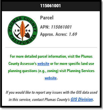
Feature Info Pop-up
Opens when a feature is clicked on. Most features when "clicked on" will have a "Pop up". This feature provides basic information about the feature that you have clicked on.
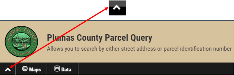
Header/Menu Bar
This will collapse if you click the "up arrow" located at left-hand edge:
Located in the lower right-hand corner of the map screen:
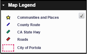
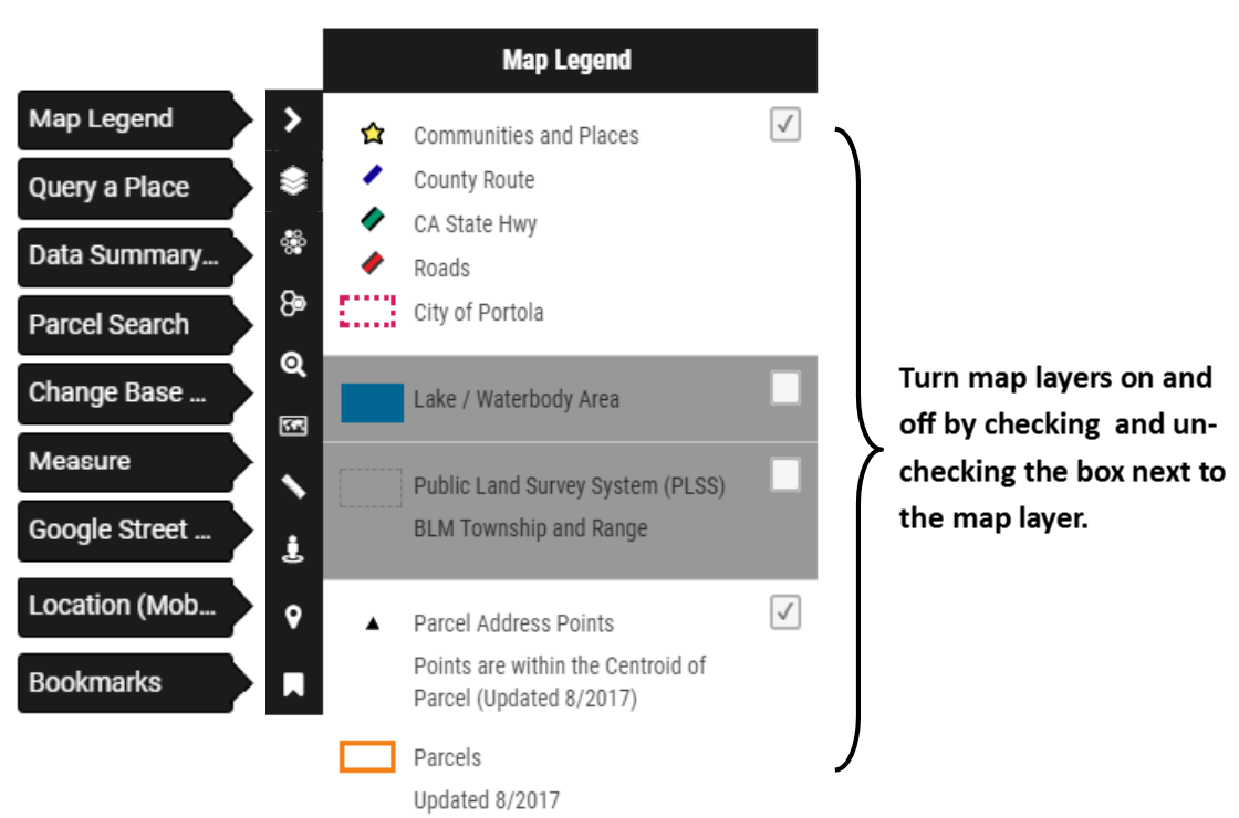
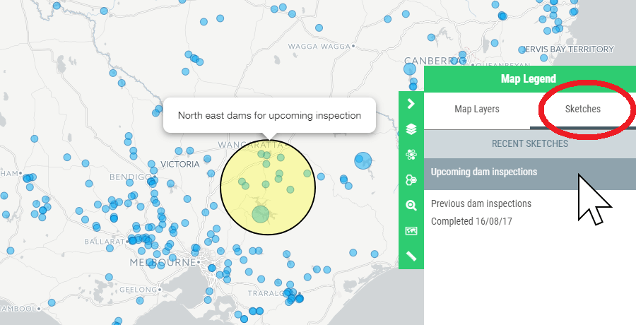
Map Legend
Expand the Map Legend window in the lower right-hand corner of the map screen. All features in the legend denoted with a "check box" can be turned "On" or "Off". Only a couple of the features will be checked when the program opens. These are preset so that your computer will be able to process the data faster. NOTE: Some layers (depending on the data source and your network speed) may take some time to render.
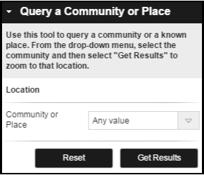
Query a Community or Place
The Query a Community or Place Tool is used to as a quick "jump-to" to a known community or a known place. Select your desired location from the drop-down menu. Click 'Get Results' and zoom to that location.
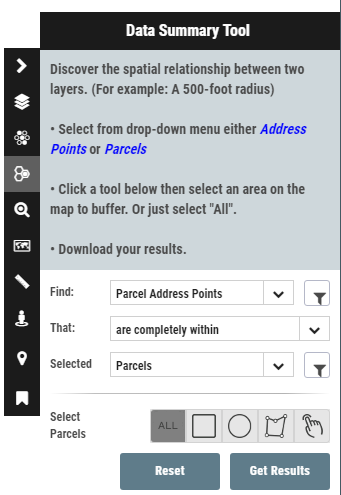
Data Summary Tool
The Data Summary Tool will allow you to select features in one layer and then find features in a second layer that meet certain criteria (e.g., intersect within a certain distance). Selection tools include radius, box, shape, and attribute filters. Click 'Get Results' and export your data.
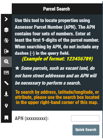
Parcel Search
Type an Assessor Parcel Number (APN) into the search box (in this format: 123456789) and click "Go". The map will automatically zoom to the location and highlight your query.
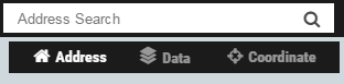
Quick Address Search, Parcel or Coordinate Search
Select an option under the address field. Type an address (select Address), coordinates (select Coordinate for Latitude/Longitude) or parcel number (select Data and type the parcel number in this format: 123456789) into the Search Box (located in the upper right-hand corner of the map screen. The map will automatically zoom to the location.
Change the Basemap
You may select from a number of basemaps including HERE aerial imagery, terrain, topographic and street maps and HERE Maps roads, satellite, hybrid, and terrain.
Create Printable PDF
Create a printable version of your customized map in Adobe's Portable Document Format (PDF). It may take some time to generate the PDF.
Measure (Draw On the Map)
Select a draw tool and the window will automatically close and you can begin adding shapes to your map to highlight an area or specify a certain point. The tool will also calculate distance and area. Double click to close polygons.
Google Street View
This tool seamlessly integrates Google's Street View with your map.
GeolocationZoom to your current location and track your movements on your mobile, tablet or netbook device. When activated, your location will be identified on the map. This feature requires the user to authorize their web browser to know their location.
Bookmarks
Quickly zoom to any saved bookmarks you created. Use the toolbar at the top of the map to create a bookmark.
-
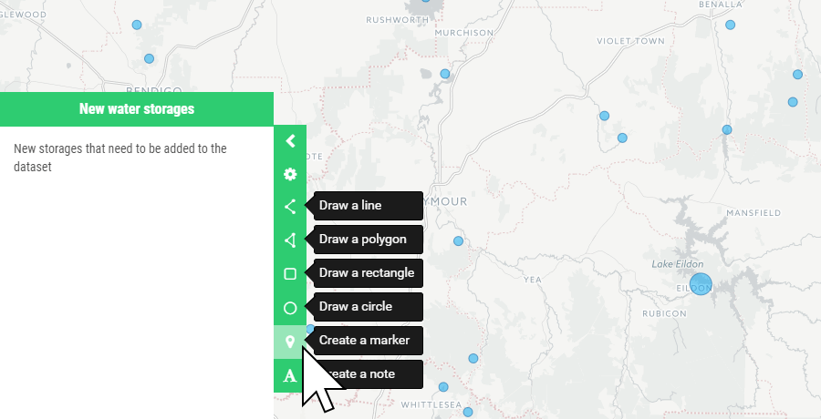
How to Use the Sketch Tool
How to Use the Sketch Tool
Click on Sketches within the Map Legend to enable the tool.
To create a sketch, click on the Sketch tab and click on the Create a Sketch button at the bottom of the Sketch panel.
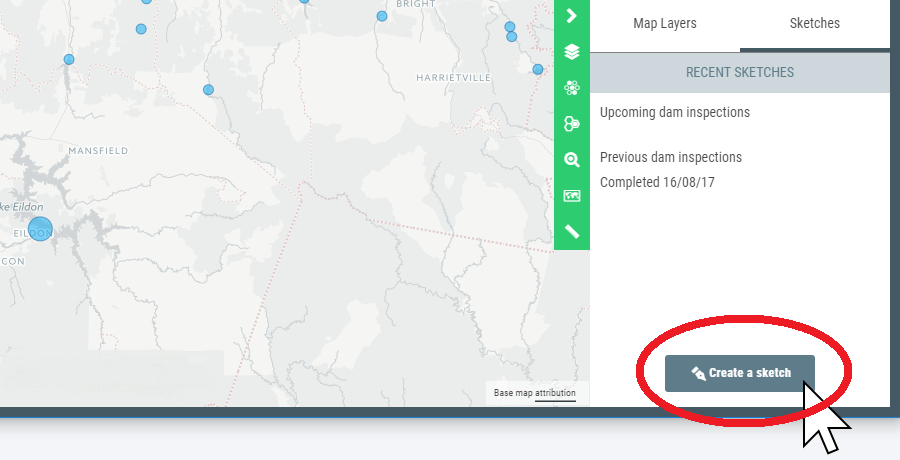
The Sketch panel will open on the left hand side of your map. Here you can set a name and description for the sketch.
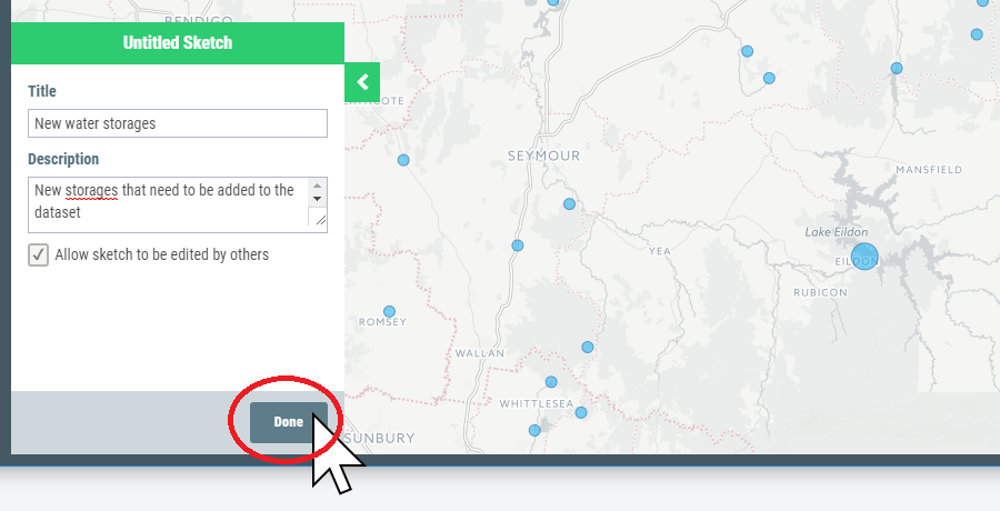
Sketches are designed to be shared and worked on collaboratively, so by default new sketches can be edited by anyone with the sketch URL. If you would like to prevent others from editing your sketch, uncheck the box "Allow sketch to be edited by others".
Once you have set your sketch name and edit settings, click Done to continue to the drawing tools.
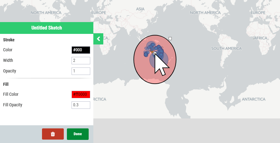
Sketch allows you to create line, polygon, rectangle, oval, marker, and text annotations on your maps.
To place a marker, select Create a marker from the tool bar and click on the map to place the marker. You can select a color from the range provided. If you need to re-position the marker, simple hover your mouse over the marker, and click and drag the marker to the preferred location.
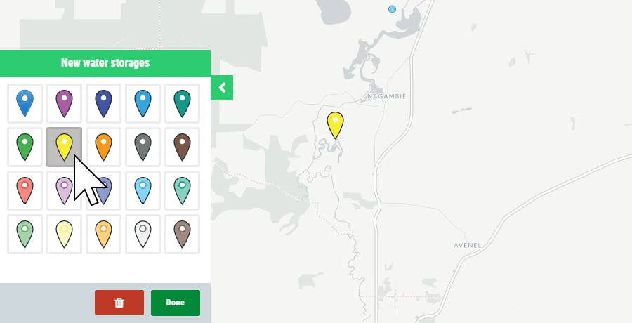
To save the marker, click the Done button.
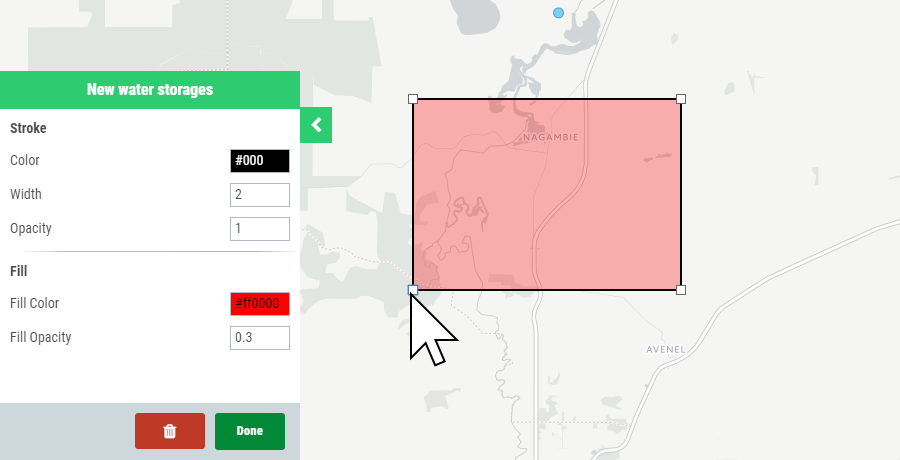
To draw a shape, click on the corresponding icon on the right of the sketch panel, and start drawing. You can adjust the line and fill colors and opacity of lines and shapes, and the text content of annotations.
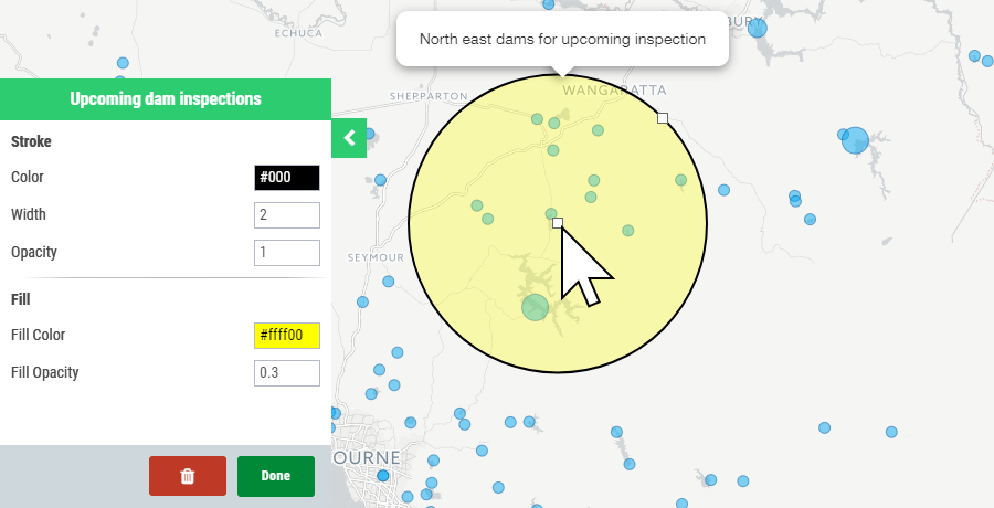
To adjust the size or position of shapes, click on the white box nodes and drag to your preferred shape or size.
NOTE:
Extremely large circles may appear to be compressed if placed near the top or bottom of the map boundary; however, they occupy the same amount of area. This is due to the distortion of the web Mercator map projection.