Historical GIS Map of the American Canal Zone in Panama
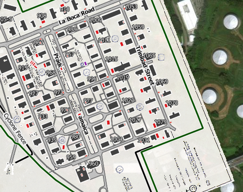
This project by geographer Drake Sprague, utilizes historical Geographic Information System (GIS) mapping methods to reconstruct the landscape and infrastructure of the American Canal Zone throughout its history, thereby safeguarding its heritage. Through meticulous research involving original maps and source documents, features are digitally drawn and aligned by hand in context of commonly used mapping platforms such as Google Maps. In this way, the locations of where life was lived and work was performed can be visualized over time throughout the Canal Zone era. The mapping task is challenging due to the significant alterations made to the terrain. Roads and buildings have changed, been swallowed up by the jungle, or have been replaced by other infrastructure. Shorelines have shifted, in many cases completely submerging early townsites. Original maps also vary in scale, detail, and accuracy, adding to the complexity of aligning features to a common geographic base. Panama's strategic location makes it susceptible to the impacts of globalism. Geopolitical, economic, and social pressures have altered the landscape and environment at an astounding rate. Since the Panama Canal was handed over to the Republic of Panama in late 1999, the former Canal Zone region in particular has undergone extensive transformation. Amidst these realities, this project will attempt to preserve a historic spatial record and also discover patterns reflecting key phases of this great American endeavor in context of the contemporary landscape. For more information about this project, contact Drake at drakesprague@outlook.com.